Move around the map#
Pan, zoom, switch the basemap, find a place by name, and read the coordinate strip and the scale bar.
The map is a flat Web Mercator view of the world, and it opens on London at zoom 6. Drag to pan and scroll to zoom. The zoom holds between levels 2 and 18, so you cannot lose the world off the edge of the screen.
The map control buttons#
A column of buttons runs down the right edge of the map, grouped by what they do. The first group holds Zoom in and Zoom out with a live zoom readout between them, plus Reset. The second group holds North, which straightens the map's bearing, and Center, which returns the view to where it started.
The remaining two buttons control what is on screen rather than where you are. One shows and hides the layer badges on the map. The other shows and hides the attribute table.
Basemaps#
Three basemaps are available: Light, Streets, and Bright. Switch between them from the view section at the bottom of the tool palette, or from the command palette. Light is the default, and it is the one to stay on when your own data is the point, because it keeps the background quiet. There is no satellite or terrain basemap.
Find a place by name#
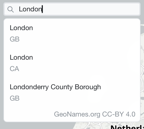
The search box sits at the top right of the map, marked Search location. Enter at least two characters, and matching places appear underneath. Each result carries its country code, so you can tell one London from another. Select one and the map flies to it. Results come from GeoNames, which the dropdown credits.
Coordinates and the feature count#
The status strip at the top left of the map tracks your cursor. It gives the position under the pointer, and it counts the features currently in view.
Coordinates start as decimal degrees, to five places, with a hemisphere letter.

Click the position cell, or focus it and press Enter or Space, and it switches to MGRS at one-metre precision. Click again to switch back. MGRS is undefined near the poles, so above 84 degrees north or below 80 degrees south the cell shows dashes instead of a reference.

Scale bar#
The scale bar sits at the bottom left and redraws as you zoom. It snaps to a round number roughly 80 pixels wide. It is metric only, in metres below a kilometre and kilometres above it, and there is no imperial option. If Geo Map cannot work out a scale for the current view, the bar shows a dash.